Multibeam systems have continued to improve and develop. Now with the right planning and execution using the correct techniques derived from extensive field experience‚ these surveys can provide seabed surface detail for environmental‚ geohazard mapping and geochemical exploration. The new techniques developed out of geochemical exploration for hydrocarbon sampling of cold seeps are also needed for environmental mapping. So map it once and use it many times.
Bluebird Geoscience has used an innovative technique that has taken the interpretation of these data from the probable to the near–certain. Bluebird personnel have supervised six sizeable x2 surveys carried out after helping pioneer the technique commercially in 2013. This technique‚ original tested and experimented with by Dan Orange (ONE) and Norman Maher when with AOA Geophysics‚ changes the way seabed data can be interpreted. See Orange et all, Oversampling for Increased Geologic Resolvability and https://dx.doi.org/10.4236/ijg.2016.75058 (Cold Seeps Associated with Benthic Communities)
It’s a simple technique but the backscatter data can be significantly upgraded with ‘double coverage’ making the geochemical exploration surveys suitable for environmental and geohazard seabed mapping from the sea surface; the most rapid acquisition and cost effective mapping technique available.
Map it once‚ use it three times‚ but only if it is mapped well the first time!
Technical Background – Multibeam Surveys
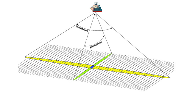
The multibeam systems measure water depth (bathymetry) from the time delay of each ping in returning but more significantly for environmental‚ geohazard‚ and geochemical exploration. It measures the backscattered acoustic energy from the seabed which relates to the hardness and roughness of the seabed. This geological data set allows the identification of cold seeps.
These seeps are both valuable bio–diverse communities in the relative environmental desert of deepwater that should be protected‚ and also sources of great insight into the hydrocarbon systems present in an area which can be a sure sign that shallow gas is present and that a geohazard risk exists.
Backscatter interpretation is complicated by the limit that any algorithm correction can make to acquired data. The correction is to account for the angle of incidence – the so–called grazing angle – of the beam with the seabed. The corrections are designed to remove the banding that is sometimes seen along the survey lines‚ including the nadir line itself.
Bluebird Geoscience helped develop a technique to upgrade the quality of backscatter data. Double coverage removes the lateral effects of the grazing angle by having each piece of seabed measured from opposite angles. Slope elevated or decreased backscatter values can be averaged out. Comparison of first and second pass data shows whether an anomaly is genuine or an artifact.
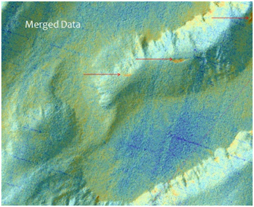
The 2x method

Courtesy Kelly Brumley(Fugro)
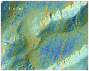
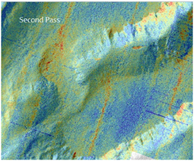
The 2x method has a 1st pass and a second pass – dominated by nadir and slope effects. But these effects are shifted between the passes. Merged data below has all the backscatter artifacts of slope and nadir removed in this case leaving three seep locations clearly visible.
See: https://dx.doi.org/10.4236/ijg.2016.75058 for more information