The innovation of x2 coverage changes the multibeam technique from a baseline reconnaissance to an accurate and detailed environmental and hazard map.
The cold seeps identified with enough certainty to allow the ‘best’ sites to be sampled is sufficient for geochemical exploration but when development is being planned the environmentally sensitive cold seeps and cold water corals need to be mapped even more accurately. Bluebird Geoscience helped develop the technique to further upgrade the quality of backscatter data. Double coverage removes the lateral effects of the grazing angle by having each piece of seabed measured from opposite angles. Slope elevated or decreased backscatter values can be averaged out. Comparison of first and second pass data shows whether an anomaly is genuine or an artifact.
Courtesy Kelly Brumley(Fugro)
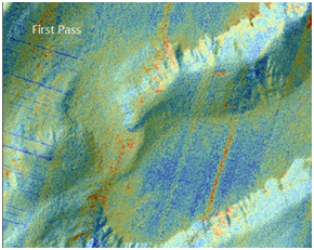
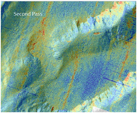
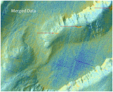
The 2x method has 1st Pass and second pass – dominated by nadir and slope effects‚ but these effects are shifted between the passes. The merged data below has all the backscatter artefacts of slope and nadir removed leaving three seep locations clearly visible.
Bluebird can provide the expertise to use this technique and get the most out of conventional multibeam surveys. We are available to plan‚ negotiate with contractors on the client’s behalf‚ assist with the evaluation of the technical aspects of tenders‚ and assure quality of results by supervising the work in the field.
See: https://dx.doi.org/10.4236/ijg.2016.75058 for more information